International Appalachian Trail
The International Appalachian Trail (IAT) is a long-distance hiking network that extends the concept of the Appalachian Trail into Canada and across the Atlantic Ocean to Europe and North Africa. It originated in Maine, United States, and traverses significant portions of the Appalachian Mountain range in New Brunswick, Quebec, and Newfoundland and Labrador. The trail's expansion is based on the geological premise that the Appalachians were once part of the ancient Central Pangean Mountains, now scattered across multiple continents. For Canadian hikers and outdoor enthusiasts, the IAT provides a unique transnational trekking experience that connects the natural landscapes of Eastern Canada with a global community of trails.
Origins and Development in North America
The International Appalachian Trail was proposed in 1994 by Maine fisheries biologist Richard Anderson, who envisioned a continuous footpath covering the Appalachian Mountain sections in Maine, New Brunswick, and Quebec not included in the original Appalachian Trail. Following route selection, physical construction of the trail took place throughout the late 1990s, establishing the initial corridor. The first person to complete a thru-hike of this original route was John Brinda from Washington State in 1997, who hiked it as part of his journey on the Eastern Continental Trail from Key West, Florida, to Cap Gaspé in Quebec. Brinda's achievement marked him as the first person to thru-hike the entire Eastern Continental Trail, bringing early attention to the IAT project. The trail's development within Canada continued with a major extension proposed in 2003 for Newfoundland and Labrador, which was planned to add approximately 1,200 kilometres of new trail across the island. The official opening of the first trail section of the IAT Newfoundland was held on September 23, 2006, marking a significant milestone in physically connecting the trail to the northernmost extent of the Appalachian Mountain chain.
Detailed Route Through Eastern Canada
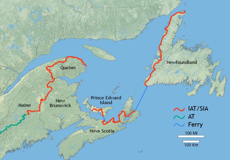
The IAT begins in the United States at Katahdin Woods and Waters National Monument in Maine and travels north to Mars Hill, Maine, before following the US-Canada border to Fort Fairfield, where it crosses into Perth-Andover, New Brunswick. The Canadian segment proceeds through the scenic Tobique River valley to Mount Carleton, the highest peak in New Brunswick, then crosses the Miramichi Highlands into the province of Quebec. In Quebec, the trail follows the Restigouche River valley and the Chic-Choc Mountains of the Gaspé Peninsula, culminating at the eastern tip of the peninsula at Cap Gaspé within Forillon National Park. From Cap Gaspé, the route involves a ferry connection across the Gulf of St. Lawrence, with a small trail section also noted in Prince Edward Island and Nova Scotia, before resuming on the island of Newfoundland at Channel-Port aux Basques. The Newfoundland leg traces the island's west coast along the Great Northern Peninsula to its northern terminus at Cape Bauld, with a final crossing of the Strait of Belle Isle leading to the geological endpoint of the Appalachian chain at Belle Isle, Newfoundland and Labrador. The trail passes through numerous significant protected areas, offering hikers a diverse range of Canadian landscapes. Key Canadian parks and protected areas along the International Appalachian Trail route include Mount Carleton Provincial Park in New Brunswick. The trail also passes through Gaspésie National Park, a Quebec national park, and Forillon National Park in Quebec. In Newfoundland, the route includes Sir Richard Squires Provincial Park, Ship's Arm Provincial Park, and Gros Morne National Park.
- Mount Carleton Provincial Park in New Brunswick
- Gaspésie National Park, a Quebec national park in the Chic-Chocs
- Forillon National Park at the tip of the Gaspé Peninsula in Quebec
- Sir Richard Squires Provincial Park in Newfoundland
- Ship's Arm Provincial Park in Newfoundland
- Gros Morne National Park, a UNESCO World Heritage site in Newfoundland
Geological Basis for Transatlantic Expansion
The expansion of the IAT into Western Europe and North Africa is fundamentally rooted in the science of plate tectonics and ancient geology. Geological evidence demonstrates that the Appalachian Mountains, along with certain mountains of Western Europe and the Anti-Atlas range in North Africa, are all parts of the ancient Central Pangean Mountains. This massive range formed when minor supercontinents collided to form the supercontinent Pangaea more than 250 million years ago. With the subsequent break-up of Pangaea, sections of the former mountain range remained with the continents as they drifted to their present locations across the Atlantic Ocean. Inspired by this compelling evidence of a shared geological past, IAT officials initiated formal plans to extend the trail's concept beyond North America. In 2009, they met with the British Geological Survey to discuss extending the IAT to the Appalachian terrains identified in Scotland, Ireland, Northern Ireland, and Wales. This meeting set off a rapid series of expansions through Europe and Northern Africa where existing national and regional trails chose to co-brand with the IAT organization, creating a linked network based on heritage rather than a single footpath.
Establishment of the Global Trail Network
Following the 2009 discussions, the International Appalachian Trail network grew quickly across the North Atlantic region. In 2010 and 2011, official chapters of the International Appalachian Trail were established in numerous countries, creating the foundation of the global network. The first trail in Europe to join was Scotland's West Highland Way, setting a precedent for other long-distance paths to affiliate. The network now includes trails in Greenland, Iceland, Norway, Sweden, Denmark, Scotland, Northern Ireland, Ireland, Isle of Man, Wales, England, Spain, Portugal, and Morocco as of July 2025. This network features several renowned natural landmarks that attract hikers from around the world, such as the Giant's Causeway in Northern Ireland, Pembrokeshire Coast National Park in Wales, and Loch Lomond and The Trossachs National Park in Scotland. The European and African trails are not physically connected to the North American trail by a bridge or path but are linked thematically and organizationally through the shared narrative of the Central Pangean Mountains. This model allows hikers to experience distinct segments of this ancient geological story on different continents, supported by local trail associations under the unifying IAT banner.
Recreational Use and Long-Distance Hiking
The International Appalachian Trail presents a formidable challenge for long-distance hikers, particularly those attempting the North American section from Maine to Belle Isle. A thru-hike requires meticulous planning for wilderness travel, resupply points in remote areas, and coordinating the necessary ferry crossings over the Gulf of St. Lawrence and the Strait of Belle Isle. The trail traverses a variety of ecosystems, including the New England-Acadian forests, boreal highlands, and coastal barrens, demanding a wide range of hiking skills from its users. For those not attempting a complete thru-hike, the trail is extensively used for section hiking, with many visitors exploring specific parks like Gros Morne or the Chic-Chocs via the IAT route. The trail also supports local economies in rural regions of Eastern Canada through hiking tourism, benefiting outfitters, guides, and accommodation providers. Its existence promotes international cooperation among trail organizations and fosters a greater public appreciation for geological history and landscape conservation across borders.
Administration and Trail Organization
The International Appalachian Trail is administered not as a single entity but as a federation of independent trail associations and chapters that agree to the shared geological theme and branding. Each national or regional chapter, such as IAT Newfoundland and Labrador or IAT Spain, is responsible for maintaining its specific trail sections, publishing guidebooks, and promoting local use. The overarching IAT organization facilitates coordination between these chapters, organizes international conferences, and manages the broader educational mission related to the Pangean geology story. Funding and maintenance rely on a combination of government grants, membership dues from national chapters, private donations, and volunteer labour from local hiking clubs. This decentralized model has proven effective for rapid international expansion, as it allows established trails to join the network without the need for new construction, instead leveraging existing infrastructure and local expertise.
Questions about International Appalachian Trail
Where does the International Appalachian Trail start and end in Canada?
The International Appalachian Trail enters Canada from Maine at Perth-Andover, New Brunswick. It travels through New Brunswick and Quebec, ending its continuous land portion at Cap Gaspé in Forillon National Park, Quebec. After a ferry crossing, it resumes in Newfoundland at Channel-Port aux Basques and continues to Cape Bauld on the Great Northern Peninsula. The geological terminus of the Appalachian chain, and thus the trail's conceptual endpoint, is Belle Isle, off the northern coast of Newfoundland.
Can you hike the International Appalachian Trail in Europe?
Yes, you can hike trails that are part of the International Appalachian Trail network in Europe. As of 2025, there are IAT-branded walking trails in Greenland, Iceland, Norway, Sweden, Denmark, Scotland, Northern Ireland, Ireland, Isle of Man, Wales, England, Spain, and Portugal. These are often established national or regional trails, such as Scotland's West Highland Way, which became the first European IAT trail. Hikers follow the specific route of each affiliated trail under the shared IAT concept.
Is the International Appalachian Trail one continuous path?
No, the International Appalachian Trail is not one continuous footpath. In North America, the trail is largely continuous from Katahdin Woods and Waters National Monument in Maine through New Brunswick to Cap Gaspé in Quebec, and again across Newfoundland from Channel-Port aux Basques to Cape Bauld. However, it requires ferry crossings over the Gulf of Saint Lawrence and the Strait of Belle Isle. In Europe and North Africa, the IAT consists of a widely dispersed network of pre-existing trails that have co-branded with the IAT organization. These trails are linked by the shared geological heritage of the ancient Central Pangean Mountains rather than physical continuity.
What is the geological reason for the trail extending to Europe?
The trail extends to Europe and North Africa due to shared geological origins. Geological evidence shows that the Appalachian Mountains, certain mountains of Western Europe, and the Anti-Atlas range in Morocco are all parts of the ancient Central Pangean Mountains. This massive range formed over 250 million years ago when minor supercontinents collided to create the supercontinent Pangaea. When Pangaea later broke apart, sections of this ancient mountain chain were carried away on the separating continental plates. This geological connection inspired the IAT's expansion to co-branded trails in Greenland, Iceland, Scandinavia, the British Isles, Spain, Portugal, and Morocco.
When did the Newfoundland section of the IAT open?
The first official trail section of the International Appalachian Trail in Newfoundland opened on September 23, 2006. This development followed the proposal of the Newfoundland and Labrador extension in 2003. When fully completed, this extension was planned to add an additional 1,200 kilometres of trail to the overall IAT network. The trail in Newfoundland picks up at Channel-Port aux Basques and follows the island's west coast up the Great Northern Peninsula to its northern terminus at Cape Bauld.
Who was the first person to thru-hike the IAT?
The first person to thru-hike the International Appalachian Trail was John Brinda from Washington State in 1997. He completed the hike as it existed at that time, which ended at Cap Gaspé in Quebec. Brinda's journey on the IAT was part of a much longer thru-hike of the Eastern Continental Trail, which begins in Key West, Florida. By completing this journey to Cap Gaspé, he also became the first person to thru-hike the entire Eastern Continental Trail. The IAT itself had been proposed in 1994 by Richard Anderson and constructed through the late 1990s.
Sources and further reading
- International Appalachian Trail (Wikipedia)
- The Trail, The IAT/SIA Council (iat-sia.org)
- International Appalachian Trail, Québec : activities (quebecmaritime.ca)
- International Appalachian Trail (islandtrails.ca)
- Sentier international des Appalaches (SIA) Québec GR A1 (tourisme-gaspesie.com)
Checked by the Garbutt Disposal desk. Last updated 2026-10-20.