Chilkoot Trail
The Chilkoot Trail is a 53-kilometre hiking route that traverses the Coast Mountains from Dyea, Alaska, to Bennett, British Columbia. It was a major transportation corridor for prospectors during the Klondike Gold Rush of the late 1890s. The trail is now cooperatively managed by Parks Canada and the U.S. National Park Service as a component of the Klondike Gold Rush International Historical Park. It draws recreational hikers and ultra-runners while preserving a significant chapter in North American history through its dual status as a Canadian National Historic Site and a U.S. National Historic Trail.
Historical Significance and Indigenous Roots
The Chilkoot Trail's history extends far beyond the gold rush, rooted in its use as a vital trade route by the Tlingit Indigenous people. Known in Tlingit as Chilkoot Dei•yi, meaning Chilkoot-owned Trail, it was a crucial corridor for exchanging coastal and interior resources. The trail's modern English name omits this reference to Tlingit ownership, and the name of the trailhead settlement, Dyea, is linguistically connected to the Tlingit name for the trail. This long Indigenous history is a foundational layer of the trail's cultural significance, preceding its famous role in the stampede for gold by many generations. The Tlingit maintained control over this route as part of their traditional trading system, which was a complex network linking coastal and interior communities. The trail provided access to resources not available in their own territories, facilitating trade with Athabascan peoples further inland. This period set the stage for the trail's dramatic transformation during the Klondike era, when tens of thousands of newcomers would traverse a path long shaped by Indigenous knowledge and commerce.
The Klondike Gold Rush Era and Infrastructure
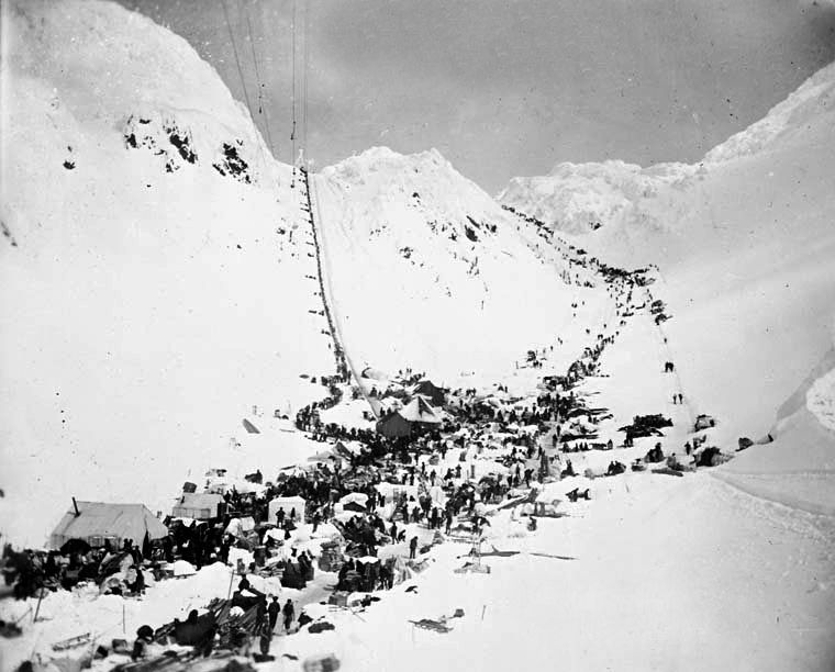
The discovery of gold in the Klondike region in 1896 precipitated a mass migration, and the Chilkoot Trail became one of the two main overland routes from the coast to the Yukon interior. It rivalled the longer but less steep White Pass trail from Skagway, with prospectors landing at the shallow-water port of Dyea to begin the arduous journey north. The trail's reputation for directness and lower cost made it immensely popular, despite its extreme difficulty and steep terrain. To ensure prospectors were prepared for the harsh Yukon winter, the North-West Mounted Police mandated that each person bring one ton of supplies, equivalent to a full year's provisions. This rule transformed the trek into a gruelling logistical challenge, as individuals had to move their massive cache in stages along the 53-kilometre path, often making dozens of trips over the same ground.
The demand for moving this gear spurred the development of a significant service industry along the trail, including the construction of several aerial tramways which represented notable engineering feats of the period. By the end of the trail's peak use, there were five distinct tramway operations competing for business on different sections of the route. Many prospectors also hired Tlingit packers, who had expert knowledge of the route, to haul gear on a per-pound rate from one campsite to the next. The trail's peak usage created active tent cities at points like Canyon City, which featured a restaurant stove and boiler, and The Scales, which hosted six restaurants, two hotels, a saloon, and many freighting offices. The gold rush period ended abruptly in 1899 when the completion of the White Pass and Yukon Route railway through the rival pass rendered the Chilkoot Trail obsolete for commercial travel, leading to the rapid abandonment of Dyea.
Modern Management, Designations and Recreation
In the latter half of the 20th century, recognition of the trail's historical value led to formal protection and cooperative management. The U.S. portion was incorporated into the Klondike Gold Rush National Historical Park in 1976, which also includes part of Pioneer Square in Seattle and sites in Skagway. The Canadian section was designated the Chilkoot Trail National Historic Site in 1987. These two entities were formally linked in 1998 to create the Klondike Gold Rush International Historical Park, commemorating the gold rush centennial. In 2022, the 26.6-kilometre Alaskan segment received the additional designation of Chilkoot National Historic Trail within the U.S. National Trails System. Today, the trail is a premier destination for backpackers and a challenging route for ultra-runners, with the fastest known time set by Geoff Roes at 5 hours and 27 minutes.
Management by Parks Canada and the U.S. National Park Service ensures maintained trails, nine designated campgrounds, and interpretive signage at historical sites. The official hiking season typically runs from late May to early September, with rangers and wardens on duty to provide safety information and historical context, though avalanche danger can linger into late May and September brings rain and colder weather. To preserve the trail's remote character and prevent ecological damage, a strict permit system limits the number of backpackers starting the trek to 50 per day. Hikers must be entirely self-sufficient, carrying all food and using backpacking stoves, as open fires are prohibited throughout the trail. The cooperative international management model balances public access with the preservation of the trail's historic artifacts and natural environments across its three climatic zones.
The Hiking Route and Key Landmarks
The trail is traditionally hiked from south to north, following the path of the stampeders over three to five days. It traverses three distinct climatic zones: coastal rainforest, high alpine, and boreal forest. The journey begins at the ghost town of Dyea, Alaska, where only foundations and scattered remnants hint at the port active between 1897 and 1899, which was also believed to be under the control of crime boss Soapy Smith. The initial segment winds through temperate rainforest along the Taiya River, passing the first campground at Finnegan's Point, named for Pat Finnegan who collected bridge-crossing tolls from stampeders.
Continuing north, the trail passes the small Pleasant Camp before reaching Sheep Camp, the largest campground on the American side with over 20 campsites and the final stop before the climb to Chilkoot Pass. From Sheep Camp, the landscape transitions to alpine terrain, leading to The Scales, a historic weighing station and tent city at the base of the Golden Stairs. This final steep ascent to the pass, with steps carved by prospectors into snow and ice, remains the trail's most demanding section. At the summit, which marks the Canada-United States border, a warming cabin and part-time warden station offer respite, and artifacts like a cache of prefabricated boats are scattered on the southeastern side. The descent into Canada passes historic tramway ruins at Stone Crib, the terminus of the Chilkoot Railroad and Transport Company's aerial tramway, and a series of alpine lakes including Crater, Morrow, and Happy Camp, before re-entering forest at Deep Lake.
The final segment leads past Long Lake and the turquoise-coloured Lake Lindeman, a major headquarters for Canadian trail operations. The trail continues past Bare Loon Lake before concluding at Bennett, British Columbia, on the shore of Lake Bennett. Here, the renovated St. Andrew's Presbyterian Church is the only gold rush-era building still intact along the trail, and pilings from old piers dot the lakeshore. Bennett also features a White Pass and Yukon Route railway depot, connecting hikers to the historic rail line back to Skagway, while the alternative Log Cabin cut-off trail to the Klondike Highway was closed by Parks Canada in 2010. Throughout the Canadian half, the trail is in the rain shadow of the Coast Mountains, making it much drier with pine forests contrasting the lush temperate rainforest on the U.S. side.
Designated Campgrounds and Facilities
Nine maintained campgrounds are spaced along the trail, and camping is permitted only at these designated sites. Each offers basic amenities such as bear-proof food storage lockers or poles, outhouses, and, in some cases, warming shelters for cooking, though sleeping inside these shelters is not allowed. Hikers must use their own tents and bring a backpacking stove, as open fires are prohibited, even though wood stoves are available in some shelters. Use of the campgrounds must be planned in advance as part of the permit process, and a U.S. Ranger Station located just north of Sheep Camp provides critical updates on weather, avalanche conditions, and history before the summit crossing. The campgrounds, in order from south to north, are Finnegan's Point, Canyon City, Pleasant Camp, Sheep Camp, Happy Camp, Deep Lake, Lake Lindeman, Bare Loon Lake, and Bennett.
- Finnegan's Point: A riverside site with a canvas warming shelter with mosquito screens, known for severe mosquitoes. It often sees few hikers due to its proximity to the trailhead.
- Canyon City: The second-largest U.S. campground, featuring a historic log cabin with a wood stove and several bunks, 16 campsites, and two outhouses near river tributaries.
- Pleasant Camp: The smallest U.S. site with a canvas shelter, usually serving as a spillover option if Sheep Camp is full, indicated by a sign at the shelter.
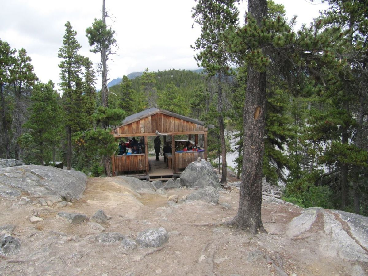
- Sheep Camp: The largest U.S. campground with over 20 sites, two canvas shelters, three outhouses, a picnic pavilion built in 2017, and a rebuilt CCC cabin from 2018.
- Happy Camp: The first campground in Canada, located in the alpine zone after descending from the pass.
- Deep Lake: Situated at tree line, marking the transition into the drier boreal forest of the Canadian half.
- Lake Lindeman: A major hub with turquoise lake views and the headquarters for Canadian trail management and operations.
- Bare Loon Lake: A forested campground near its namesake lake.
- Bennett: The trail's terminus, with a campground near the historic St. Andrew's Church, a railway depot, and private houses.
Trail Conditions, Challenges and Visitor Management
The Chilkoot Trail presents specific physical challenges and seasonal hazards that require careful preparation from hikers. The most difficult section is universally recognized as the climb from Sheep Camp over Chilkoot Pass via the Golden Stairs, a steep incline where prospectors carved steps into snow and ice. Avalanche danger is a serious concern on the approach to the pass and can persist into late May, while large snow fields can slow progress early in the season. During the summer, the coastal rainforest section can be muddy and obstructed with boulders, a condition described by gold rush stampeders as the worst piece of trail. The alpine zone between Sheep Camp and Happy Camp is barren and exposed, with the risk of being caught in poor weather, which is why wardens may offer the summit warming cabin as an emergency shelter.
The trail's management strategy is designed to mitigate these risks while controlling environmental impact. A daily limit of 50 backpackers starting the trail is enforced through a permit system to prevent overuse and maintain the remote wilderness character. The official hiking season when rangers are on-duty and trail crews are on-site usually runs from late May to early September, with peak demand from June through August. Hikers are required to attend a briefing at the U.S. Ranger Station near Sheep Camp, which covers the route over the pass and current conditions. The trail's status as a challenging ultra-run is confirmed by the fastest known time of 5 hours and 27 minutes, set by Geoff Roes, contrasting sharply with the typical 3 to 5 day backpacking itinerary.
Artifacts and Preservation
The Chilkoot Trail is an open-air museum, with numerous physical remnants of the gold rush era preserved along its length. These artifacts are protected by law and provide a direct tangible link to the events of the late 1890s. The cold, preserving properties of the snow at high altitudes have kept many items intact for over a century, and the management agencies have placed interpretive signs adjacent to notable historical sites and objects to educate hikers without disturbing the artifacts. Parks Canada and the National Park Service maintain full-time trail maintenance crews who work to stabilize these artifacts while ensuring the trail remains passable, and the warming cabin at Canyon City specifically houses a collection of gold rush-era artifacts for public viewing.
- Dyea and Canyon City: Building foundations, a large restaurant stove, and a boiler are visible in these ghost town sites.
- Trail Corridor: Old telegraph and tram wires are exposed adjacent to the trail in many sections.
- The Scales and Golden Stairs: A high concentration of artifacts exists here, including many remnants of wooden structures and abandoned equipment, as this is where many prospectors turned back.
- Chilkoot Pass: A cache of intact prefabricated boats made of canvas and wood is located on the southeastern side of the pass.
- Stone Crib: The collapsed wooden structure of the Chilkoot Railroad and Transport Company's aerial tramway terminus is visible.
- Deep Lake Area: Many boat and boat-related artifacts are visible near the outlet river and small canyon.
- Lake Bennett: Pilings from bygone piers dot the lakeshore and an assortment of cans and other metal artifacts are scattered throughout the woods.
The preservation approach for the Chilkoot Trail prioritizes in-situ protection of artifacts. This means objects are left where they were found to maintain the historical integrity of the landscape. This is a key reason for the strict regulations against removing any objects from the trail. The method allows the trail to function as a continuous historical document. Each artifact contributes to the narrative of the Klondike stampede and the immense effort required to traverse this mountain pass. Numerous artifacts, including remnants of wooden structures and prefabricated boats, remain visible along the route.
Questions about Chilkoot Trail
Where does the Chilkoot Trail start and end?
The Chilkoot Trail begins at the historic townsite of Dyea, Alaska, located near Skagway. It traverses 53 kilometres north through the Coast Mountains, crossing the Canada-United States border at Chilkoot Pass, and concludes at Bennett, British Columbia, on the shore of Lake Bennett. The traditional hiking direction is from south to north, following the path of the Klondike stampeders. At Bennett, hikers can connect with the White Pass and Yukon Route railway for a return trip to Skagway.
Do I need a permit to hike the Chilkoot Trail?
Yes, a permit is mandatory for all overnight hikers. To protect the trail from overuse, Parks Canada and the U.S. National Park Service enforce a strict limit of 50 backpackers starting the trail each day. Permits must be obtained in advance through the official reservation system, particularly for the peak summer months from June through August. The permit fee contributes to trail maintenance, ranger services, and the preservation of historic sites along the route.
How long does it take to hike the Chilkoot Trail and what is the difficulty?
Most hikers complete the trail in three to five days, depending on their pace and weather conditions. The trail is considered strenuous, with the most difficult section being the climb from Sheep Camp to Chilkoot Pass via the Golden Stairs. This segment involves significant elevation gain on steep, often snowy terrain. Ultra-runners have completed the route in under a day, with the fastest known time recorded by Geoff Roes at 5 hours and 27 minutes.
What is the historical significance of the Chilkoot Trail?
The Chilkoot Trail is a 33-mile trail through the Coast Mountains from Dyea, Alaska to Bennett, British Columbia. It was a major access route from the coast to Yukon goldfields during the Klondike Gold Rush from 1896 to 1899. It was the most direct and popular overland route for prospectors. The U.S. portion was designated a National Historic Landmark in 1978 and is part of Klondike Gold Rush National Historical Park. The Canadian portion was designated Chilkoot Trail National Historic Site in 1987. In 1998, these sites joined to form Klondike Gold Rush International Historical Park. In 2022, the Alaskan portion was designated Chilkoot National Historic Trail.
What are the main challenges or dangers on the trail?
The main challenges include steep and difficult terrain, particularly the Golden Stairs ascent to Chilkoot Pass. The trail features variable and harsh weather, with avalanche danger that can linger into late May. Hikers must be prepared for snowfields, rain, and cold temperatures. The trail passes through a large avalanche chute. The remote and exposed alpine landscape between the pass and Happy Camp poses risks. Hikers must be self-sufficient, carry all supplies, and use only designated campgrounds. A backpacking stove is required as open fires are prohibited.
What facilities are available at the campgrounds and can I have a campfire?
The nine designated campgrounds provide basic amenities including tent pads, bear-proof food storage lockers or poles, and outhouses. Some have canvas or log warming shelters with wood stoves for cooking, but sleeping inside is not permitted. Hikers must bring their own tents, sleeping bags, and a backpacking stove, as open fires are prohibited throughout the entire trail. The shelters are for warming and cooking only, and all cooking must be done on a portable stove.
Sources and further reading
- Chilkoot Trail (Wikipedia)
- Chilkoot Trail National Historic Site, Parks Canada (parks.canada.ca)
- Chilkoot Trail, Skagway (skagway.com)
- Travelogue: The Chilkoot Trail (greatcanadiantrails.com)
- Finding Adventure on the Chilkoot Trail, IMPACT Magazine (impactmagazine.ca)
Checked by the Garbutt Disposal desk. Last updated 2026-10-22.