Bruce Trail
The Bruce Trail is Canada's oldest and longest marked hiking trail, spanning more than 890 kilometres along the Niagara Escarpment from Queenston on the Niagara River to Tobermory at the tip of the Bruce Peninsula. Established in the early 1960s, the trail traverses a UNESCO World Biosphere Reserve and is a vital recreational and conservation corridor for an estimated seven million Ontarians living within 100 kilometres of its route. Managed by the Bruce Trail Conservancy and a network of nine volunteer clubs, the path passes through diverse landscapes, including urban areas, conservation lands, and pristine wilderness, with over 400 kilometres of associated side trails. The trail is named after Bruce County and the Bruce Peninsula, which in turn honour James Bruce, 8th Earl of Elgin, a former Governor General of the Province of Canada from 1847 to 1854.
History and Foundation
The concept for the Bruce Trail originated in 1959 from a meeting between Ray Lowes and Robert Bateman of the Federation of Ontario Naturalists. Lowes envisioned a continuous public footpath along the entire Niagara Escarpment, a vision that quickly gained traction among outdoor enthusiasts and conservationists. The first official meeting of the Bruce Trail Committee was held on September 23, 1960, with four founding members: Ray Lowes, Philip Gosling, Norman Pearson, and Dr. Robert McLaren. These individuals became instrumental in transforming the idea into reality, with Philip Gosling taking a leading role as Trail Director to secure land access and build community support along the proposed route. Gosling and a team of volunteers visited major towns to discuss the vision and solicit help from landowners, leading to the establishment of regional clubs along the trail's length by 1963.
The Bruce Trail Association was formally incorporated as a non-profit organization in Ontario on March 13, 1963, and published its first newsletter, Bruce Trail News, that same year, with membership growing to 200. Dr. Aubrey Diem, an assistant professor of Geography at the University of Waterloo, compiled the trail's first official guidebook in 1965 to aid hikers in navigation. A significant milestone was reached in 1967, Canada's Centennial Year, with the unveiling of the cairn marking the trail's northern terminus in Tobermory. The organization, renamed the Bruce Trail Conservancy (BTC) in 2007, continues to expand and protect the trail corridor, with a major acquisition in August 2021 of the nearly 400-acre Maple Cross Nature Reserve on the Saugeen (Bruce) Peninsula, its largest to date, which allowed for a 1.8-kilometre extension in the Cape Chin area.
Route and Geography
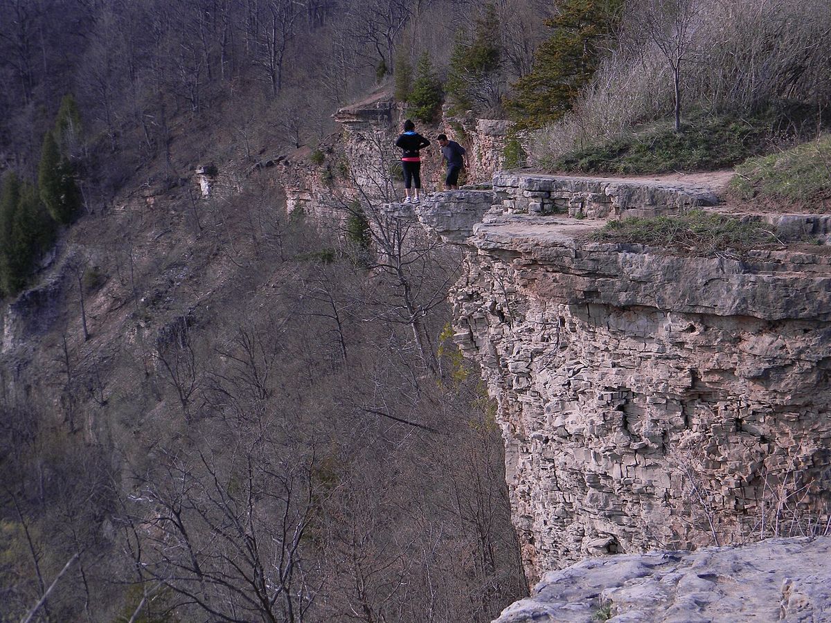
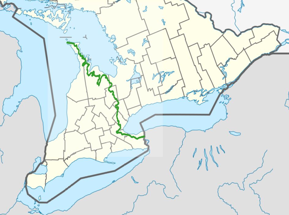
The Bruce Trail begins at a cairn in a parking lot in Queenston, Ontario, on the Niagara River, approximately 160 metres from General Brock's Monument on the easterly side of the monument's park grounds. From there, it travels north through the Niagara Peninsula, passing through St. Catharines and its surrounding wine country near the Short Hills Bench, before continuing due north along the Niagara Escarpment. The route connects major population centres including Hamilton, Burlington, Milton, Halton Hills, and Walters Falls, then proceeds through Owen Sound and Wiarton before reaching its final destination at the northern cairn in Tobermory on the Bruce Peninsula. This path connects hikers to a wide array of protected natural areas operated by various levels of government and conservation authorities, forming a continuous green corridor.
Key parks and conservation areas along the route include Woodend Conservation Area in Niagara-on-the-Lake, Battlefield Park in Stoney Creek, Dundas Valley Conservation Area in Dundas, the Hamilton-Brantford Rail Trail, Mount Nemo Conservation Area, Rattlesnake Point Conservation Area, and Crawford Lake Conservation Area. Further north, the trail passes through Mono Cliffs Provincial Park and the Bruce Peninsula National Park, located between Georgian Bay and Lake Huron near the northern tip of the Bruce Peninsula. Only about half of the trail runs through public land, with the remainder relying on formal agreements with private landowners or following road allowances. The BTC actively works to acquire land along what it deems the 'optimum route' to secure the trail's permanent future and minimize road walking, as these agreements with private landowners can be withdrawn at any time.
- Southern Terminus: Cairn in Queenston, near the Niagara River and Niagara Falls.
- Northern Terminus: Cairn in Tobermory, Bruce Peninsula, gateway to Fathom Five National Marine Park.
- Major Urban Centres: St. Catharines, Hamilton, Burlington, Milton, Owen Sound.
- Notable Protected Areas: Dundas Valley Conservation Area, Mono Cliffs Provincial Park, Bruce Peninsula National Park.
- UNESCO Site: Trail follows the Niagara Escarpment World Biosphere Reserve.
- Land Composition: Approximately 50% public land, remainder on private property or roads.
- Primary Geological Feature: Follows the edge of the Niagara Escarpment.
Natural Environment and Conservation Challenges
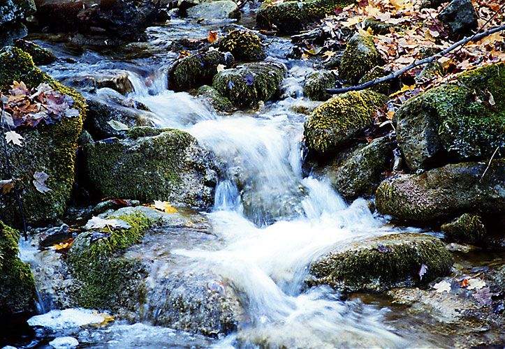
The Bruce Trail corridor presents the rich biodiversity and dramatic geology of the Niagara Escarpment, one of nineteen UNESCO World Biosphere Reserves in Canada. The route features numerous waterfalls where rivers and streams cascade over the escarpment edge, with the world-famous Niagara Falls accessible via a side trail from the main route. The landscape supports a wide range of plant and animal life, including slow-growing centuries-old coniferous trees rooted directly on the limestone lip of the escarpment itself. Notable natural sites include the Cheltenham Badlands, a striking example of erosion exposed by historical farming practices, which is visible from the trail.
An estimated seven million people live within 100 kilometres of the escarpment, creating significant environmental pressures from urban development, agriculture, and resource extraction like quarrying. Specific threats include the development of golf courses, housing subdivisions, and active quarries that fragment the natural landscape. The trail's own popularity, especially near cities, can lead to overuse, erosion, and damage from careless users, which paradoxically threatens the very quality and long-term viability of the trail experience. The Bruce Trail Conservancy's core mission is the permanent protection of the escarpment landscape through land acquisition, holding conservation easements, and promoting responsible use to mitigate these combined pressures.
Organization, Maintenance, and Trail Markings
The Bruce Trail is managed by the Bruce Trail Conservancy (BTC), which moved from an association model and is currently headquartered at 55 Head Street in Dundas, Ontario. The BTC is responsible for the overall stewardship of the trail, including land acquisition, conservation policy, and coordinating the efforts of its nine regional clubs. These clubs, each covering a specific geographic section, are staffed by dedicated volunteers who handle local trail operations. Their defined responsibilities include obtaining and maintaining landowner permissions, organizing trail construction, and performing all inspection and maintenance work within their region, a model established successfully in the trail's early years.
Maintenance work is extensive and ongoing, involving building and repairing footbridges over streams and gullies, constructing stairs and switchbacks to climb slopes, installing stiles over fences, and rerouting portions worn down by overuse. The BTC and its clubs also organize educational programs and award badges to hikers who complete the entire trail or individual sections under prescribed conditions set by the organization. The trail is marked with a standardized system where the main trail is blazed with white rectangular markers approximately 3 cm wide by 8 cm high, with turns indicated by two stacked blazes offset in the direction to take. The associated side trails, which total over 300 kilometres according to some measurements, are marked with identical blazes in blue, while the official BTC logo is a white lozenge with black text and drawings used for signage but not for on-trail navigation.
Long-Distance Hiking, Running, and Endurance Events
The Bruce Trail is a premier destination for long-distance hikers and endurance athletes, with the BTC and its clubs organizing structured 'end to end' hike events that challenge participants to complete large sections over two to three days in order to hike an entire club section. Beyond organized group hikes, many individuals undertake self-guided thru-hikes of the entire 890-plus kilometre route, a significant logistical and physical undertaking. These athletic pursuits highlight the trail's varied use from casual walking to extreme endurance challenges. Notable relay events have also taken place on the trail, often serving dual purposes of athletic achievement and fundraising. In 2008, the Highlands Trailblazers Nordic Ski Team completed a relay-style run of the entire trail in eight days, starting in Tobermory on June 24 and finishing in Queenston on July 1, as both a training event and a fundraiser. The following year, in an event called the Blaze Race, two 10-person teams running continuously set a new end-to-end relay record of 3 days, 23 hours, and 10 minutes. In 2012, adventurers Fred Losani, Peter Turkstra, Mark Maclennan, and Teemu Lakkasuo hiked the trail over a month to raise funds and awareness for inner-city food programs in Hamilton and for the BTC's 50th anniversary, incorporating live webcam and satellite phone interactions with students to discuss nutrition, healthy living, and trail conservation.
| Year | Event / Achievement | Key Participants or Details |
|---|---|---|
| 1995 | First Fastest Known Time (FKT) | First recorded speed record for running the entire trail. |
| 2008 | Highlands Trailblazers Relay | Team completed trail in 8 days (June 24, July 1) for training and fundraising. |
| 2009 | Blaze Race Relay Record | Two 10-person teams set record of 3 days, 23 hours, 10 minutes. |
| 2012 | Month-Long Awareness Hike | Fred Losani, Peter Turkstra, Mark Maclennan, Teemu Lakkasuo raised funds for BTC and Hamilton nutrition programs. |
Publications and Guidebooks for Hikers
A substantial collection of publications supports those planning to hike or learn about the Bruce Trail, ranging from official guides to personal narratives. The essential resource is the official Bruce Trail Reference: Maps and Trail Guide, published by the BTC, with the 31st edition released in 2023. This guide comes as a three-ring binder containing a great deal of background information about the trail as well as detailed fold-out maps of each section that can be easily removed to accompany hikes, and it is updated every few years to reflect trail changes. For those interested in the trail's history, David E. Tyson's 2017 book, Trail to the Bruce: The Story of the Building of the Bruce Trail, provides a detailed account of how the trail in its present form came to exist, documenting the efforts of its founders.
Nicholas Ruddick's 2021 book, The Bruce Trail End to End: Niagara to Tobermory the Hard Way, is a photographic documentary of a hike along the entire trail. It is based on the author's 72-part online photoblog and contains 300 illustrations. Beth Gilhespy's ongoing series, Walking through Time, first published in 2023, explores the geology of the Niagara Escarpment on the various sections of the Bruce Trail. The official handbook of the trail is The Bruce Trail Reference: Maps and Trail Guide, which contains background information and detailed fold-out maps. Another book, Trail to the Bruce: The Story of the Building of the Bruce Trail by David E. Tyson, provides a detailed history of the trail.
- Bruce Trail Reference: Maps and Trail Guide (31st Ed., 2023): The official handbook with removable, fold-out section maps and background information.
- Trail to the Bruce (2017) by David E. Tyson: A detailed history of the trail's construction and early development.
- The Bruce Trail End to End (2021) by Nicholas Ruddick: A photographic documentary and paperback based on a 72-part online photoblog.
- Walking through Time (2023-) by Beth Gilhespy: An ongoing series of books exploring the geology of the escarpment along the trail.
- Bruce Trail News (1963-): The association's newsletter, first published in the year of incorporation.
Conservation and Land Securement Efforts
The long-term security of the Bruce Trail depends on the permanent protection of the land corridor it follows, a complex task given the mix of public and private ownership. The Bruce Trail Conservancy's strategic plan focuses on acquiring land or securing conservation easements along the 'optimum route' to create a continuous, protected footpath. This work is critical because agreements with private landowners, while generous, can be withdrawn at any time, potentially breaking the trail's continuity. Using road allowances is considered a suboptimal solution for both safety and the hiking experience, so land acquisition remains a top priority for the organization and its supporters.
The BTC's most significant acquisition to date was the purchase of nearly 400 acres known as the Maple Cross Nature Reserve in August 2021, located in the Cape Chin area on the Saugeen Peninsula. This purchase allowed the Bruce Trail to be extended an additional 1.8 kilometres through a new protected area. Fundraising for such acquisitions often ties into the trail's recreational use, as seen in the 2012 hike that raised awareness and funds for both inner-city programs and the BTC itself. The organization's success relies on a combination of donor support, government partnerships, and the volunteer efforts of its nine regional clubs who help monitor and care for the land.
Questions about Bruce Trail
Where does the Bruce Trail start and end?
The Bruce Trail begins at a cairn in Queenston, Ontario, on the Niagara River near Niagara Falls, situated about 160 metres from General Brock's Monument on the easterly side of the monument's park grounds. It travels north along the Niagara Escarpment for more than 890 kilometres to end at another cairn in the village of Tobermory, located at the northern tip of the Bruce Peninsula on Lake Huron. The northern terminus in Tobermory also serves as the jumping off point for Fathom Five National Marine Park. The entire route is designed as a continuous footpath connecting these two points.
Who owns and maintains the Bruce Trail?
The land the Bruce Trail traverses is owned by a mixture of the Government of Ontario, local municipalities, local conservation authorities, private landowners, and the Bruce Trail Conservancy (BTC). The BTC, headquartered at 55 Head Street in Dundas, is the charitable organization responsible for the overall stewardship, conservation, and coordination of the trail. Day-to-day maintenance is performed by volunteers from nine regional clubs, each responsible for a specific section of the route, under the guidance of the BTC. These clubs handle tasks like building bridges, stairs, and rerouting worn sections.
Is the entire Bruce Trail on public land?
Approximately half of the trail runs through public land. The trail also runs partly on private property and partly on road allowances. On private property, the Bruce Trail Conservancy has agreements with landowners to allow foot traffic. The Bruce Trail Conservancy is involved in acquiring land along what it calls the optimum route.
What are the trail markings for the Bruce Trail?
The main Bruce Trail is marked with rectangular white blazes, approximately 3 centimetres wide by 8 centimetres high, painted on trees, posts, or rocks. Navigational turns are indicated by stacking two blazes off centre to show the direction to take. The extensive network of associated side trails, measuring over 400 kilometres in total, is marked with identical blazes in blue. The official Bruce Trail Conservancy logo is a white lozenge with black text and drawings, but it is used for signage rather than on-trail navigation.
Can you run or bike the entire Bruce Trail?
The Bruce Trail is designated as a footpath, and the agreements with many private landowners specifically restrict the right of way to foot traffic only. Therefore, cycling is not permitted on the vast majority of the trail, especially on private land sections. Running is permitted and has a history on the trail, including organized relay events and individual Fastest Known Time (FKT) attempts, with the first FKT set in 1995. All users must stay on the marked trail to respect private property and minimize environmental impact.
What is the best guidebook for hiking the Bruce Trail?
The most comprehensive and authoritative guide is the official Bruce Trail Reference: Maps and Trail Guide, published by the Bruce Trail Conservancy. The 31st edition was released in 2023. It is designed as a practical resource with a three-ring binder containing detailed, removable fold-out maps for each section and extensive background information. It is updated regularly to reflect trail reroutes and changes, making it the essential tool for planning any hike. Other valuable books include historical accounts and photographic documentaries of end-to-end hikes.
Sources and further reading
- Bruce Trail (Wikipedia)
- Explore the trail (brucetrail.org)
- An Audacious Idea, The Bruce Trail Turns 50 (inthehills.ca)
Checked by the Garbutt Disposal desk. Last updated 2026-10-22.